 Catalogue PIGMA
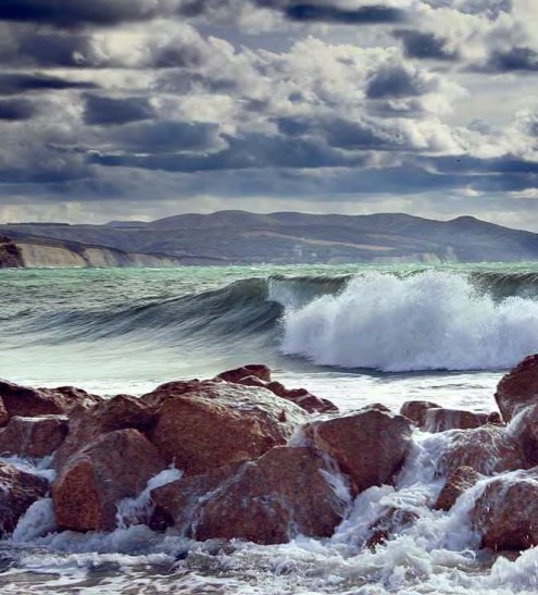
Norwegian Sea
Type of resources
Available actions
Topics
Keywords
Contact for the resource
Provided by
Years
Formats
Representation types
Update frequencies
status
Scale
Resolution
-
Assessments run at AFWG provide the scientific basis for the management of cod, haddock, saithe, redfish, Greenland halibut and capelin in subareas 1 and 2. Taking the catch values provided by the Norwegian fisheries ministry for Norwegian catches1 and raising the total landed value to the total catches gives an approximate nominal first-hand landed value for the combined AFWG stocks of ca. 20 billion NOK or ca. 2 billion EUR (2018 estimates).
-
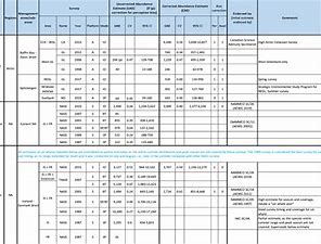
The purpose of this table is to present the best available abundance estimates for cetacean species in areas of relevance to the work of NAMMCO. It is intended to be used as a starting point for researchers, and the original sources are provided if additional information is required. The Scientific Committee of NAMMCO maintains a Working Group on Abundance Estimates, composed of invited experts in the field as well as some Committee members. This Working Group meets periodically to review new abundance estimates from recent surveys or, in some cases, re-analyses of older data. The reports of the Working Group are brought to the Scientific Committee at their annual meetings, and used to formulate advice on stock status, allowable removals or other matters. In most cases, the Scientific Committee will formally endorse estimates approved by the Working Group, and if so, this is indicated on the Table. Some estimates have been endorsed by the Scientific Committee of the International Whaling Commission (IWC).
-
.jpg)
NAMMCO is an international regional body for cooperation on conservation, management and study of cetaceans (whales, dolphins and porpoises) and pinnipeds (seals and walruses) in the North Atlantic. The members of NAMMCO — Faroe Islands, Greenland, Iceland and Norway — are committed to sustainable and responsible use of all living marine resources, including marine mammals. Through regional cooperation, the NAMMCO member countries aim to strengthen and further develop effective conservation and management measures for marine mammals. Acknowledging the rights and needs of coastal communities to make a sustainable living from what the sea can provide, such measures should be based on the best available scientific evidence and user knowledge and take into account the complexity and vulnerability of the marine ecosystem. The NAMMCO Agreement focuses on consolidating and advancing scientific knowledge of the North Atlantic marine ecosystem as a whole, and understanding better the role of marine mammals in this system. In 2017 NAMMCO member countries reaffirmed their cooperation through the Nuuk Declaration. NAMMCO Catch database: This database of reported catches is searchable and it is possible to filter the information by country, species or area. It is also possible to sort the different columns in ascending or descending order and to show up to 100 entries per page. Carry-over from previous years are included in the quota numbers, where applicable. NAMMCO aims to ensure that this database is kept up to date with correct and validated catch data. The reported catch data for harbour seals in Greenland prior to 2012 is not included in the database due to known sources of error. This includes identified errors in where harbour seal catch data has been entered in hunting reports, and cases of species misidentification.
-

NCAR was established by the National Science Foundation in 1960 to provide the university community with world-class facilities and services that were beyond the reach of any individual institution. More than a half-century later, we are still delivering on that mission. NCAR provides the atmospheric and related Earth system science community with state-of-the-art resources, including supercomputers, research aircraft, sophisticated computer models, and extensive data sets. From its founding, NCAR was meant to provide the atmospheric research community with the shared resources necessary to work on the most important scientific problems of the day. Not much has changed. The hundreds of scientists who work here research all things atmospheric — which includes everything from the microphysics of cloud formation and the chemistry of air pollution to large-scale planetary waves and the impact of increased greenhouse gases on our climate. Since the atmosphere interacts with everything it touches, its crucial to investigate those interactions, too.
-
SEAPOP (SEAbird POPulations) is a long-term monitoring and mapping programme for Norwegian seabirds that was established in 2005. The programme covers seabird populations in Norway, Svalbard and adjacent sea areas, and will provide and maintain base-line knowledge of seabirds for an improved management of this marine environment. The data analyses aim to develop further models of seabird distribution and population dynamics using different environmental parameters, and to explore the degree of covariation across different sites and species. This knowledge is urgently needed to distinguish human influences from those caused by natural variation.
-

We assembled a dataset of 14C-based productivity measurements to understand the critical variables required for accurate assessment of daily depth-integrated phytoplankton carbon fixation (PP(PPeu)u) from measurements of sea surface pigment concentrations (Csat)(Csat). From this dataset, we developed a light-dependent, depth-resolved model for carbon fixation (VGPM) that partitions environmental factors affecting primary production into those that influence the relative vertical distribution of primary production (Pz)z) and those that control the optimal assimilation efficiency of the productivity profile (P(PBopt). The VGPM accounted for 79% of the observed variability in Pz and 86% of the variability in PPeu by using measured values of PBopt. Our results indicate that the accuracy of productivity algorithms in estimating PPeu is dependent primarily upon the ability to accurately represent variability in Pbopt. We developed a temperature-dependent Pbopt model that was used in conjunction with monthly climatological images of Csat sea surface temperature, and cloud-corrected estimates of surface irradiance to calculate a global annual phytoplankton carbon fixation (PPannu) rate of 43.5 Pg C yr‒1. The geographical distribution of PPannu was distinctly different than results from previous models. Our results illustrate the importance of focusing Pbopt model development on temporal and spatial, rather than the vertical, variability.
-
The gyre index constructed here from satellite altimetry is related to core aspects of the North Atlantic subpolar gyre, meridional overturning circulation, hydrographic properties in the Atlantic inflows toward the Arctic, and in marine ecosystems in the northeast Atlantic Ocean. The data series spans the period January 1993 to September 2018. Data description: Monthly gyre index from January 1993 until September 2018. The data is provided in one comma separated value (csv) file with the following entries on each row: year, month, index value. The index is normalized, i.e. it has a zero mean and unit standard deviation. Positive (negative) gyre index reflects stronger (weaker) than average surface circulation of the North Atlantic subpolar gyre.
-
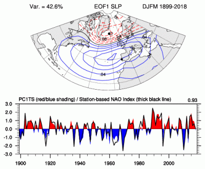
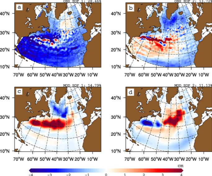
The principal component (PC)-based indices of the North Atlantic Oscillation (NAO) are the time series of the leading Empirical Orthogonal Function (EOF) of SLP anomalies over the Atlantic sector, 20°-80°N, 90°W-40°E. These indices are used to measure the NAO throughout the year, tracking the seasonal movements of the Icelandic low and Azores high. These movements are illustrated in the Figures on this page. Positive values of the NAO index are typically associated with stronger-than-average westerlies over the middle latitudes, more intense weather systems over the North Atlantic and wetter/milder weather over western Europe.
-

MISSION ATLANTIC assesses the whole Atlantic, and ecosystem components at risk from natural hazards and the consequences of human activities, including individual regional Case Studies, and their interconnectivity. To do this, Mission Atlantic develops IEAs for seven regional Case Studies, in sub-Arctic and Tropical regions of the Atlantic Ocean, ranging from shelf seas to the mid-Atlantic Ridge: 1) Norwegian Sea 2) Celtic Sea 3) Canary Current 4) North Mid Atlantic Ridge 5) South Mid Atlantic Ridge 6) Benguela Current 7) South Brazilian Shelf
-
The International Whaling Commission was set up under the International Convention for the Regulation of Whaling which was signed in Washington DC on 2nd December 1946. The preamble to the Convention states that its purpose is to provide for the proper conservation of whale stocks and thus make possible the orderly development of the whaling industry. The Commission undertakes extensive study and research on cetacean populations, develops and maintains scientific databases, and publishes its own peer reviewed scientific journal, the Journal of Cetacean Research and Management. A list of catches since the moratorium came into place (in the 1985/6 Antarctic Season) up to 2019 (download link).